Environmental justice in air permitting
On this page: Environmental Justice Summary requirements overview | How to submit a complete Environmental Justice Summary | Environmental Justice Report Tool | Submit the Environmental Justice Summary | Community engagement and outreach considerations | Next steps and timelines | Modeling requirements determination | Public Records | Disproportionately impacted community permitting rule | Contact us
Help in your language: Free language assistance services are available to you. To request assistance in Spanish or another language, please email cdphe_apcd_outreach@state.co.us. Please include the topic and “language assistance” in the subject line. Please also link to the specific information you’d like to access, if possible, such as a web page or document.
For questions or assistance related to the Environmental Justice Report Tool for Air Quality Regulation 3, please email cdphe_apcd_ejreports@state.co.us with “EJ Summary” and the facility name in the subject line.
Environmental Justice Summary requirements overview
Starting July 15, 2023, all applicable permit applicants must submit an Environmental Justice Summary prior to submitting their permit application. A complete Environmental Justice Summary is required for most new or modified air permits submitted to the Air Pollution Control Division.
Disproportionately impacted communities generally have more environmental pollution exposure and may experience higher levels of environmental health harm. Many of these communities are home to people of color and low-income families. The Environmental Justice Summaries must cover environmental health data about the community where the air pollution source operates.
This web page provides information about how to create and submit a complete Environmental Justice Summary.
How to submit a complete Environmental Justice Summary
A complete Environmental Justice Summary includes the following components:
- The Environmental Justice Report.
- A satellite image of the facility with a one-mile radius of the surrounding area.
- The Environmental Justice Summary for Air Quality Regulation online submission form. Visit the division’s electronic submissions web page for more information and to access the form. Questions in the form are available online so you can compile all required information before submitting the form.
Environmental Justice Report Tool for Air Quality Regulation 3
The Environmental Justice Report Tool for Air Quality Regulation 3 is designed for air pollution permit applicants to use when implementing the Disproportionately Impacted Community Permitting Rule adopted by the Air Quality Control Commission in May 2023.
The Environmental Justice Reporting Tool for Air Quality Regulation 3 automatically generates an Environmental Justice Report required for the Environmental Justice Summary. The tool provides information on:
- Whether a facility is located in a Disproportionately Impacted Community.
- The Colorado EnviroScreen score and environmental, health, and sociodemographic data for the census block group where a facility is located.
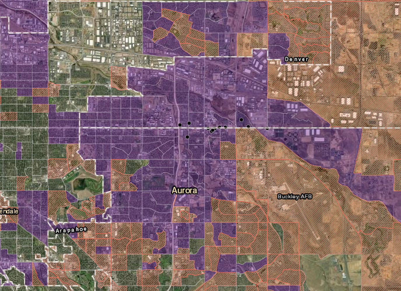
Figure 1. The map in the Environmental Justice Report for Air Quality Regulation 3 shows Disproportionately Impacted Communities. Cumulatively Impacted Communities are shown in purple and Socioeconomically Vulnerable Communities are shown in orange. Green indicates vegetation on the map.
The Environmental Justice Report Tool for Air Quality Regulation 3 is designed for air pollution permit applicants to use when implementing the Disproportionately Impacted Community Permitting Rule adopted by the Air Quality Control Commission in May 2023.
The Environmental Justice Reporting Tool for Air Quality Regulation 3 generates an Environmental Justice Report required for the Environmental Justice Summary. The tool provides information on:
- Whether a facility is located in a Disproportionately Impacted Community.
- The Colorado EnviroScreen score and environmental, health, and sociodemographic data for the census block group where a facility is located.
Submit the Environmental Justice Summary
To submit a complete Environmental Justice Summary follow these three required steps:
Step 1: Generate an Environmental Justice Report.
Step 2: Generate a one-mile buffer map. Both the EJ Report and the one-mile buffer map are needed for step three below.
Step 3: Submit the Environmental Justice Summary online submission form.
- Submit supplemental Environmental Justice Summary information using the Air Pollution Control Division’s online form. You must upload the Environmental Justice Report when you submit the form. You can also upload additional attachments.
The steps above must be completed to submit a complete Environmental Justice Summary as required by Air Quality Regulation 3.
Additional how-to guidance for small businesses is also available.
Community engagement and outreach considerations
Community engagement is encouraged in Air Quality Regulation 3. For tips on how to conduct effective outreach, visit CDPHE’s community engagement, outreach, and public participation best practices website. More information on community engagement considerations for Air Quality Regulation 3 is available on the frequently asked questions web page.
Please upload documentation as an attachment when you submit the Environmental Justice Summary online submission form for any community engagement efforts conducted. If community engagement efforts are ongoing at the time of submission or planned for after Environmental Justice Summary submission, please send attachments and documentation to cdphe_apcd_ejreports@state.co.us after the permittee completes any community engagement.
If you have questions or would like to discuss specific community engagement efforts that your facility could conduct for a particular permit and community, email cdphe_apcd_ejreports@state.co.us with the facility name in the subject line.
Next steps and timelines
Once all required Environmental Justice Summary materials are received, the Air Pollution Control Division’s Environmental Justice in Permitting team reviews them. The permit applicant will receive a confirmation number via email upon submission of their Environmental Justice Summary. Once reviewed and verified, the division sends the applicant a verification number and a downloadable letter of concurrence via email. The verification number and letter of concurrence confirm the complete Environmental Justice Summary was received, reviewed, and verified by the division. Note: The confirmation number and verification number are two different numbers noting different steps in the permit application process.
The division works to process complete Environmental Justice Summary submissions as quickly as possible. The team generally completes this process within 14 days.
The facility must include the division-issued verification number or division-verified letter of concurrence with the permit application.
Modeling requirements determination
If a modeling determination (form APCD-114) is required for the emission source, you should submit your modeling determination request at the same time you submit the Environmental Justice Summary. Follow the instructions on form APCD-114. If you are unsure whether a modeling determination is required, please consult the Air Pollution Control Division’s Air Quality Modeling Guidance for Permits website.
Note: As of September 2024, you must submit the Environmental Justice Summary confirmation number, sent via email by the division, when submitting Form APCD-114.
Public Records
The Environmental Justice Summary, including the Environmental Justice Report, is part of the permit record. The Air Pollution Control Division uploads these documents to the division’s public records database along with the permit application.
Learn more about air permit public records and how to access them online.
If you need assistance requesting any public records, such as a facility’s complete Environmental Justice Summary, contact the division’s records management team.
Environmental Justice Summary Dashboard
Use the Environmental Justice Summary Dashboard to find whether an Environmental Justice Summary was recently verified by the division for a specific air pollution source. This online tool shows a list and map of division-verified Environmental Justice Summaries to date.
You can search by facility name or zip code to get an early indication about future air permit proposed projects in your neighborhood. The tool provides information about facility location, whether the facility is located in a disproportionately impacted community, and more. Learn more about the different ways you can use the Environmental Justice Summary Dashboard.
This tool is regularly updated to provide a timely snapshot of division-verified Environmental Justice Summaries through an interactive, visual map.
Disproportionately impacted community permitting rule
For more information, visit the disproportionately impacted community permitting rule web page.
Contact us
Email cdphe_apcd_ejreports@state.co.us with “EJ Summary” and the facility name in the subject line.
Small businesses can contact the Air Pollution Control Division’s Small Business Assistance Program for assistance: cdphe_apcd_sbap@state.co.us.