User Guide: Environmental Justice Report Tool for Air Quality Regulation 3
Help in your language: Free language assistance services are available to you. To request assistance in Spanish or another language, please email cdphe_apcd_outreach@state.co.us. Please include the topic and “language assistance” in the subject line. Please also link to the specific information you’d like to access, if possible, such as a web page or document.
For questions or assistance related to the Environmental Justice Report Tool for Air Quality Regulation 3, please email cdphe_apcd_ejreports@state.co.us with “EJ Summary” and the facility name in the subject line.
Introduction
The Environmental Justice Report Tool for Air Quality Regulation 3 is designed for regulated entities and CDPHE Air Pollution Control Division staff. The tool is used when implementing the Disproportionately Impacted Community Permitting Rule adopted by the Air Quality Control Commission in May 2023. Beginning on July 15, 2023, Regulation 3 requires all applicable permit applicants to submit an Environmental Justice Summary for each census block group in which a source is located as part of the permit application (Reg. 3 Part III.B.5.)
The Environmental Justice Report Tool generates a report that includes most of the information required as part of a complete Environmental Justice Summary, including:
- Whether the facility is located in a Disproportionately Impacted Community.
- The Colorado EnviroScreen score.
- Environmental, health, and sociodemographic data for the census block group(s) in which the facility is located.
Permit applicants must submit the complete Environmental Justice Summary, including the Environmental Justice Report and a satellite image of the facility with a one-mile radius, to the division before submitting their permit application.
The report generated by the tool does not provide all the information that must be included in the Environmental Justice Summary. Pursuant to Reg. 3 Part III.B.5, other information must also be included in the Environmental Justice Summary, including but not limited to a summary of any community engagement conducted by the permit applicant with the surrounding community. Permit applicants must provide that additional information separately. However, the report generated by this tool will provide detailed information that permit applicants can use to inform their community engagement strategies and strategies to reduce pollution burdens on the surrounding community.
More information is available on the division’s Environmental justice in air permitting web page, which includes detailed Guidance for Incorporating Environmental Justice into Permitting Procedures.
The user guide below explains how to use the Environmental Justice Report Tool. If you have questions, email cdphe_apcd_ejreports@state.co.us with “Environmental Justice Report Tool” in the subject line.
The first time you visit the Environmental Justice Report Tool, you will see a pop up window providing basic information about the tool along with a link to this user guide. The pop up window also provides links to web pages that provide more information such as:
- Air Pollution Control Division’s Environmental justice in permitting.
- Air Pollution Control Division’s Small Business Assistance Program.
- CDPHE Environmental Justice Program.
- Colorado EnviroScreen.
Visit these web pages for more information about topics such as the definition of Disproportionately Impacted Community and compliance assistance support.
Click “OK” to enter the tool.

Figure 1. The splash screen appears when you enter the Environmental Justice Report Tool. It provides links to resources on using the tool, as well as resources on small business assistance, the CDPHE Environmental Justice Program, and Colorado EnviroScreen. Click the “OK” button to enter the tool.
The default view of the map shows the satellite image of the state of Colorado. Census block groups highlighted in purple or orange are Disproportionately Impacted Communities. Regulation 3 identifies two categories of Disproportionately Impacted Communities:
- Socioeconomically Vulnerable Communities.
- Cumulatively Impacted Communities.
Each category is color-coded on the map. The legend on the right side of the map shows what each color represents.
- Light orange shows census block groups that are Socioeconomically Vulnerable Communities.
- Light purple shows census block groups that are Cumulatively Impacted Communities.
- Census block groups not highlighted in light orange or light purple are not Disproportionately Impacted Communities.
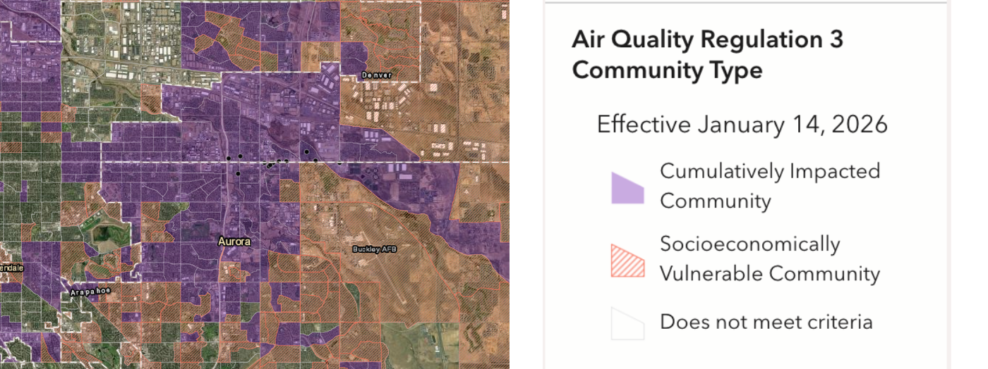
Figure 2. The image on the left is the main map of the Environmental Justice Report Tool. The tool displays data by census block group. The image on the right is a legend of the color blocks shown on the main map. The highlighted orange shows census block groups that are Socioeconomically Vulnerable Communities. Light purple shows census block groups that are Cumulatively Impacted Communities. Green indicates vegetation on the map.
A Socioeconomically Vulnerable Community is defined as a census block group in which over:
- 40% of households are low-income (meaning they are at or below 200% of the federal poverty level);
- 40% of the population identify as people of color;
- 50% of households are housing-cost burdened (meaning they spend more than 30% of household income on housing costs); Or
- 20% of the population is linguistically isolated (meaning no adults in a household speak English well).
The definition of Socioeconomically Vulnerable Community comes from Colorado law (C.R.S. § 24-4-109(2)(b)(II)).
A Cumulatively Impacted Community is defined as a census block group that has a Colorado EnviroScreen Percentile Score above 80. A Colorado EnviroScreen Percentile Score above 80 indicates that census block group bears more cumulative environmental, climate, and socioeconomic risks than other census block groups in Colorado. Colorado EnviroScreen combines data from 35 different environmental, climate, socioeconomic, health, and demographic indicators to calculate the Colorado EnviroScreen percentile score. Colorado law instructs the Air Quality Control Commission to use the 80th percentile in Colorado EnviroScreen to identify communities that experience cumulative impacts (C.R.S. § 24-4-109(5)(a)(I)).
Interact with the map using the controls defined and depicted in the images below:
- The Search bar lets you search the map by address or coordinate location.
- The Basemap button, which is the four-square icon, allows you to change the map layer. Various basemaps are available that show streets, terrain, topography, and other visual features
- The Measure button allows you to measure a distance in a line or shape
- The Zoom Controls allow you to make the map extent bigger or smaller. You can also use the scroll wheel on your mouse to zoom in and out of the map.
- The Home button returns the map to its original extent which shows all of Colorado.
- The Layers button allows you to add or hide counties, mobile home communities, and community types on the map.
- The Location button allows you to find your location without typing in an address.
- The Reset button resets the map’s orientation.

Figure 3. The Environmental Justice Report Tool’s search bar, basemap button, and measure button functions can be found on the top right corner of the tool. In the top-left corner, the tool includes zoom controls and a home button.
If you click on a census block group, a pop up window will display more detailed information about its Disproportionately Impacted Community classification and why the census block group does or does not meet the definition of an Air Quality Regulation 3 Disproportionately Impacted Community.
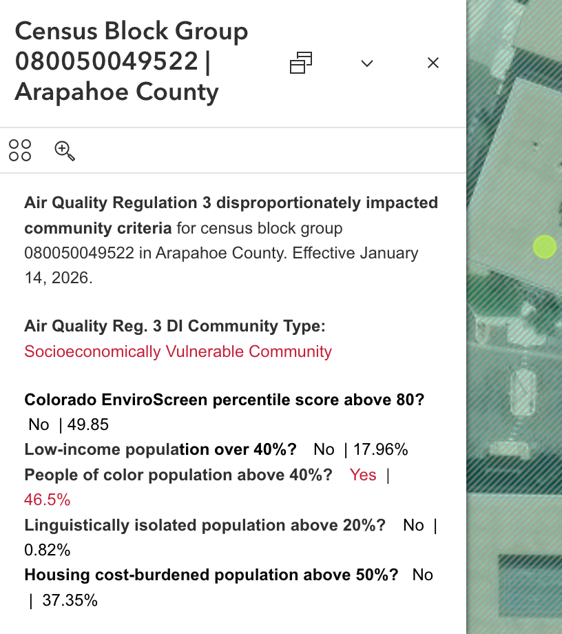
Figure 4. A pop-up window will show detailed data about a selected census block group, including location, Colorado EnviroScreen score, and if it is located in a Disproportionately Impacted Community.
Use the Search Bar to enter an address or coordinates, Zoom Controls, or the scroll wheel on your mouse to navigate to a location on the map.
Note: For the best user experience, use the Environmental Justice Report Tool on a desktop or laptop computer. Some functions are not compatible with a smaller screen size.
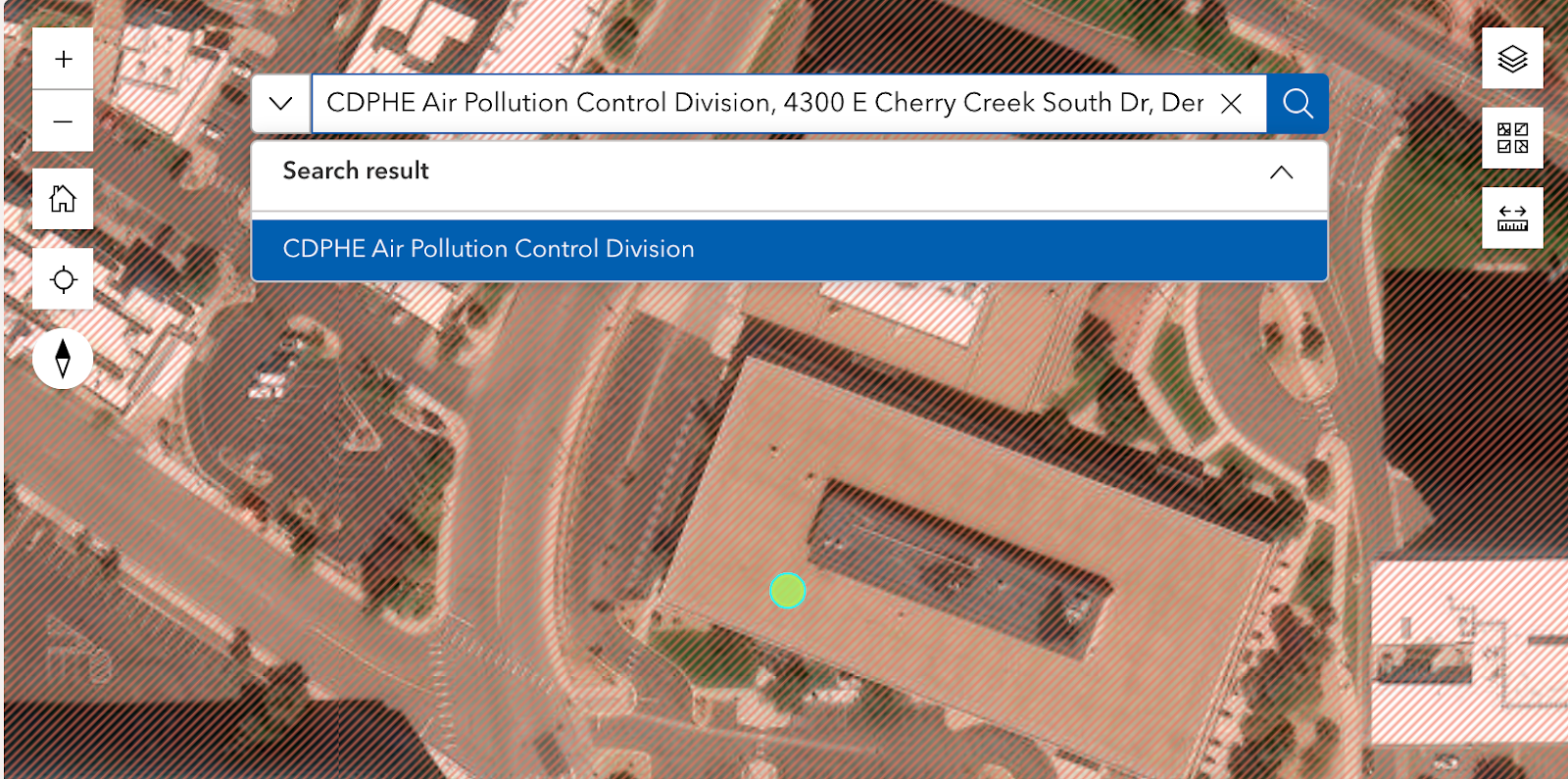
Figure 5. When an address is entered into the search bar, the location will appear for selection on the search bar dropdown, and the location will then appear from an aerial view on the map screen.
Select Step 1: Reg 3 EJ Report from the options in the left-hand panel under Instructions. Click on the surrounding area of your facility to highlight the census block group containing your facility.
A pop-up will appear for that census block group.
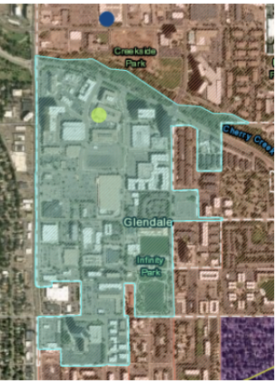
Figure 6. A highlighted census block group appears after clicking on the surrounding area of the facility.
At the top of the pop-up, download the attached Reg 3 EJ Report PDF. Save this PDF for your submission.
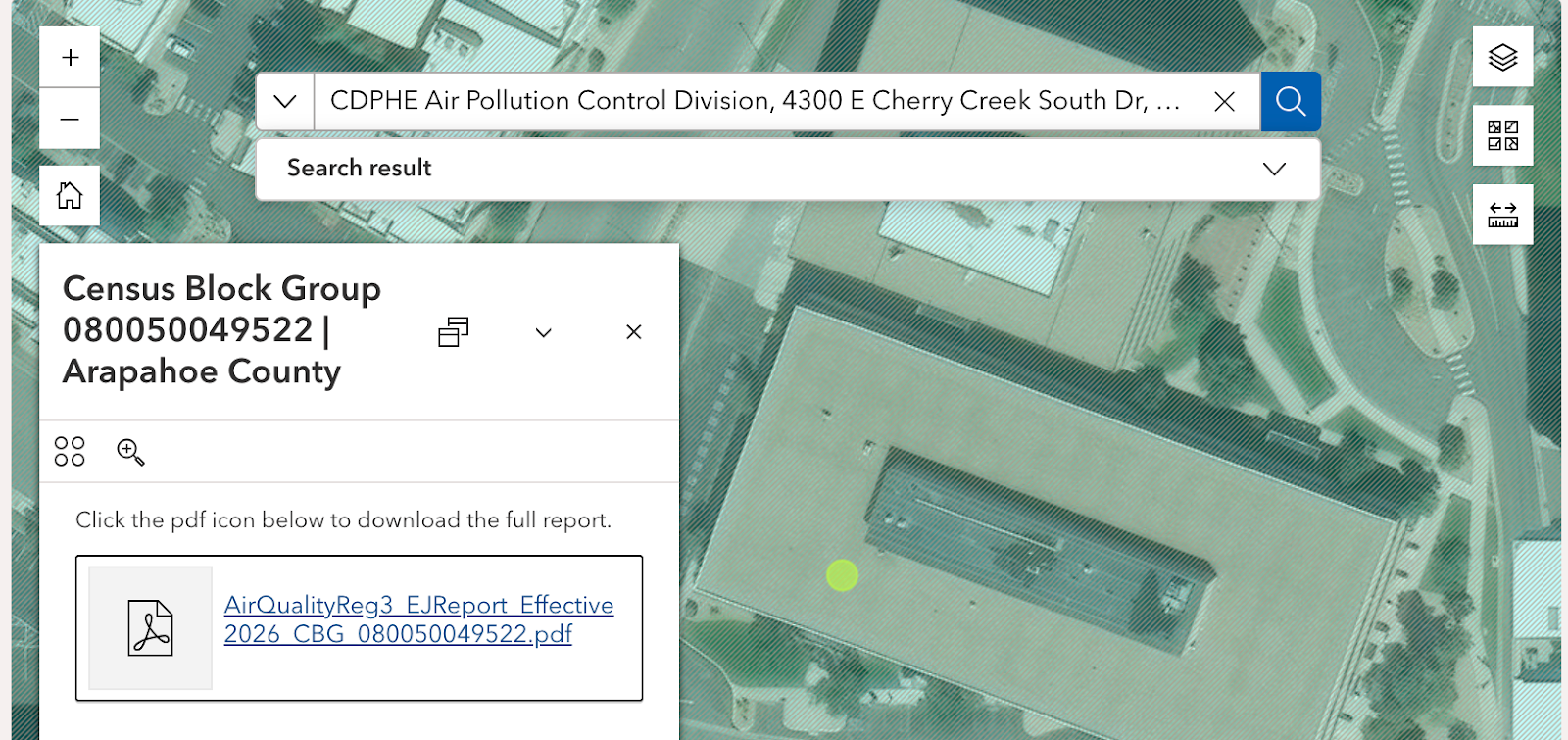
Figure 7. When the Environmental Justice Report is generated, a link will appear. Click on the link highlighted in blue to open the report in a new window.
Note that if a facility is large enough to span the boundary of multiple census block groups, the permit applicant must generate a separate Environmental Justice Report for each census block group in which the facility is located. Only one Environmental Justice Report can be generated at a time. If a permit applicant is submitting an application for multiple facilities, they must generate a separate Environmental Justice Report for each facility.
Select Step 2: One-mile Buffer map from the options in the left-hand panel under Instructions, and click on the location tool icon located in the left-hand panel below. Note that after clicking on the location tool icon, a blue dot will appear with your cursor on the map. Select your facility’s location, and once you’ve added the location, a one-mile buffer around the location will be automatically generated.

Figure 8. To create a one-mile buffer map around the facility, click on the location button to select the exact location of the facility.
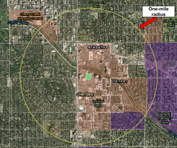
Figure 9. Clicking on the location button creates a one-mile radius of the facility. The one-mile radius is shown within a solid yellow circle.
Scroll down the left-hand panel and click on the blueprint button. The print result may take a few seconds to appear. When it is ready, an item will appear in the Results tab located to the right of the Print Template tab. Click on the link to the Facility one-mile buffer, and when the print window appears, choose save as a PDF.
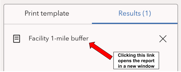
Figure 10. After a point is located and the one-mile buffer map has been generated, a link will appear in the Results tab. Click on Facility 1-mile buffer to open the map in a new window.
Understanding the Environmental Justice Report
The Environmental Justice Report provides an overview of the environmental and socioeconomic data available in Colorado EnviroScreen for the selected location in Colorado. The report details whether the location is within a Disproportionately Impacted Community, and if so, whether it is a Socioeconomically Vulnerable Community or Cumulatively Impacted Community based on the criteria established by Regulation 3. All underlying data in the report comes from Colorado EnviroScreen version 2.0. For more information about the data and methodology used in Colorado EnviroScreen see the Colorado EnviroScreen Technical Documentation.
Note: Each Environmental Justice Report generated lists the Disproportionately Impacted Community Layer of Colorado EnviroScreen version number used to generate the report. You can confirm this information by checking the bottom right footer of any pages within the report.

Figure 11. Footer of an Environmental Justice Report showing the date the report was created and the Disproportionately Impacted Community Layer of Colorado EnviroScreen version number used to generate the report.
Section 1. Environmental Justice Summary for Air Quality Regulation 3
The Environmental Justice Summary section displays the summary information for determining whether or not the census block group identified in the report meets the criteria for Disproportionately Impacted Community based on Regulation 3. The census block group is labeled as one of the following:
- Socioeconomically Vulnerable Community.
- Cumulatively Impacted Community.
- Not a Disproportionately Impacted Community.
This section also includes a map of the census block group where the facility is located.
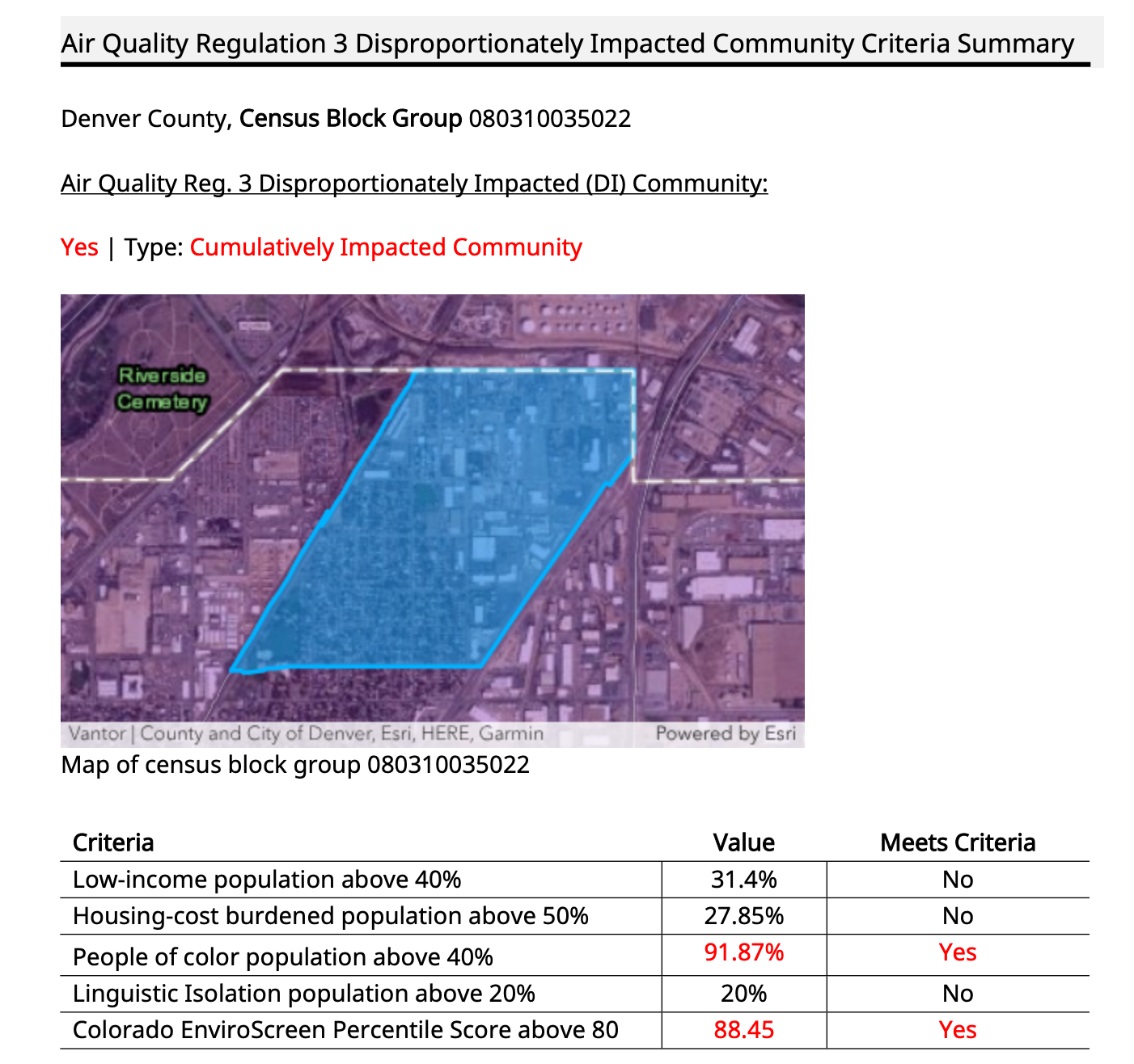
Figure 12. The Environmental Justice section of an Environmental Justice Report shows the census block group identified and whether or not the census block group is designated as a Disproportionately Impacted Community. If the census block group is a Disproportionately Impacted Community per Regulation 3, it is designated as either a Socioeconomically Vulnerable Community or a Cumulatively Impacted Community. The section also includes percentages for low-income populations, people of color population, limited English proficiency population, housing cost-burdened population, and Colorado EnviroScreen percentile score.
Section 2: Environmental Justice overview
The Environmental Justice Overview section shows the five component percentile scores for the selected census block group. The five categories are:
- Environmental exposures.
- Environmental effects.
- Climate vulnerability.
- Sensitive populations.
- Demographics.
The component scores are aggregated into the final Colorado EnviroScreen Score as shown in the figure below. For a detailed explanation of the Colorado EnviroScreen Scoring Methodology, read pages 29 to 34 of the Colorado EnviroScreen Technical Documentation.
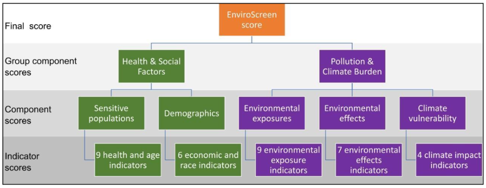
Figure 13. This graphic shows how the Colorado EnviroScreen score is calculated.
Image description:
- 35 indicator scores factor into the final Colorado EnviroScreen score. Indicator scores include:
- 9 health and age indicators;
- 6 economic and race indicators;
- 9 environmental exposure indicators;
- 7 environmental effects indicators; and,
- 4 climate impact indicators.
- Indicator scores factor into the five Component scores:
- Sensitive populations score calculated from the 9 health and age indicators;
- Demographics score calculated from the 6 economic and race indicators;
- Environmental exposures score calculated from the 9 environmental exposure indicators;
- Environmental effects score calculated from the 7 environmental effects indicators; and,
- Climate vulnerability score calculated from the 4 climate impact indicators.
- Component scores factor into two Group component scores:
- Health and Social Factors score calculated from the Sensitive populations and Demographics component scores.
- Pollution and Climate Burden score calculated from the Environmental Exposures, Environmental Effects, and Climate vulnerability component scores.
- The final Colorado EnviroScreen Score is calculated based on the two Group Component scores.
Section 3: Pollution and Climate Indicators.
The Pollution and Climate Indicators section lists the environmental exposures, environmental effects, and climate vulnerability indicator percentile scores for the selected census block group. For the Pollution and Climate indicator data sources and methodology see pages 40 to 53 of the Colorado EnviroScreen Technical Documentation.
Permit applicants should use the specific pollution and climate indicator data to inform strategies to mitigate the potential impacts of their permit application where feasible and appropriate. As discussed in greater detail in the division’s Guidance for Incorporating Environmental Justice into Permitting Procedures, the division will review this data and may work with a permit applicant to identify appropriate mitigation measures to reduce cumulative impacts experienced by a community.
For most indicators, the indicator is highlighted in red if it is above the 80th percentile to indicate that the census block group where the facility is located faces higher risks based on that indicator than other Colorado communities. However, less than 20% of census block groups in Colorado have oil and gas facilities or mining locations. Accordingly, all census block groups in Colorado score above the 80th percentile for proximity to these two types of facilities because even having zero facilities puts a community in the top 20%. As a result, the Environmental Justice Report highlights a census block group in red if it is above the 85th percentile for mining facilities and above the 90th percentile for oil and gas facilities. This ensures that only census block groups with a greater number of facilities than the statewide average of zero are highlighted on the Environmental Justice Report.
Section 4: Health and Social Indicators.
The Health and Social Indicators section lists the sensitive populations and demographics percentile scores for the selected census block group. For the Pollution and Climate indicator data sources and methodology, see pages 40 to 53 of the Colorado EnviroScreen Technical Documentation.
Permit applicants should use the specific sensitive populations and demographic indicator data to inform community engagement strategies for their permit application where feasible and appropriate. As discussed in greater detail in the division’s Guidance for Incorporating Environmental Justice into Permitting Procedures, the division will review this data and may work with a permit applicant to identify appropriate community engagement strategies based on the specific characteristics of a community.
More map features
The top toolbar in the Environmental Justice Report Tool includes many additional features that may be helpful to advanced users.
Data download
Figure 14. Shows the button for data download.
All data in the Environmental Justice Report Tool is available to download for free. Click on the “Data Download” button in the top window bar to download the underlying geographic information system, or GIS, files.
Other map features
Figure 15. The resources bar at the top of the Environmental Justice Report Tool includes links to the Environmental justice in air permitting web page, the submission guidance, frequently asked questions, data download button, and the add data button.
At the top right corner of the Environmental Justice Report Tool, more resources are available for users. The EJ in Air Permitting, User Guide, and FAQs buttons direct users to the web pages with these resources. The button on the far right allows advanced users to add data to the tool. Users can upload their own GIS files to the tool for advanced mapping applications.
Contact us
For questions about the Environmental Justice Report Tool for Regulation 3, email cdphe_apcd_ejreports@state.co.us with “EJ Report Tool” in the subject line.
For questions about air quality permitting more broadly or specific permitting requirements under Regulation 3, visit the Air Pollution Contacts web page to contact the appropriate individual for the type of permit you plan to submit.